| No | Start | Finish | Transport | ||||||
| From | Day | Time | To | Day | Time | Type | Cost | ||
| 1 | Day 1 | SaiGon | 25-Jan | 18:55 | Kuala Lumbur | 25-Jan | 21:50 | Flight | $ 80.00 |
| 2 | Day2 | Kuala Lumbur | 26-Jan | 17:35 | Kathamandu | 26-Jan | 19:45 | Flight | $ 115.87 |
| Arrival in Kathmandu at noon. Afternoon : prepare equipment, food. Get entrance permit also TIMS card at Tourism Information Board in Kathmandu. | |||||||||
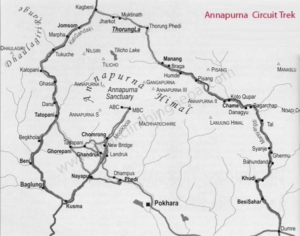
| 3 | Day3 | Kathmandu – Ghermu (1130 m) – Car and Jeep (8-10hrs drive) Rent a private car to Benshisahar then swicth to Jeep to Ghermu. 7 – 8 scenic drive through Prithivi high way |
|||||||
| 4 | Day4 | Ghermu – Dharapani (1900 m) Ghermu – Jagat – Chamche – Tal – Karte -Dharapani Begins with the rocky trail following the Marsyandi Rivers steadily uphill to Tal at 1675m, the first village in the Manang district. We walk through a wide and flat valley, then the journey continues making up and down to Dharapani at 1890m. |
|||||||
| 5 | Day5 | Trek to Koto (2640 m) Dharapani – Bagarchap – Dannaqyu – Koto There we find a stone entrance chorten typical of the Tibetan influenced villages from here northwards. We then visit the Bagarchhap at 2160m that offers the typical flat roofed stone houses of local Tibetans design although the village which is still in the transition Zone before the dry highlands. Before we reach to Danaque we walk through a pine forest and mani walls. With often rough and rocky, the trail climbs to Tyanja at 2360m, & then continues through forest, but near the river, to Kopar at 2590m. |
|||||||
| 6 | Day6 | Trek to Upper Pisang (3310 m) Koto – Chame – Bhratang ¬- Dhukur Pokhari – Upper Pisang As we reach the Chame, the headquarters of the Manang district, we are rewarded by the fine views of Annapurna II as you approach Chame & two small hot springs by the town. From there the trail joins to climb to Pisang, which sprawls between 3200m & 3300m. We continue through the drier upper part of the Manang district, cut off from the full effect of the monsoon by the Anapurna Range. |
|||||||
| 7 | Day7 | Trek to Manang (3500m). Upper Pisang – Ghyaru (3730m) – Ngawal (3680m) – Humde (3330m) – Bhraga – Manang Leaving Pisang, we have an alternate trails north and south of the Marsyangdi River which meet up again at Mungji. The southern route by Hongde, with its airstrip, at 3325m involves less climbing than the northern route via Ghyaru. We pick the northern route though there are better views on the trail that follows the northern bank of the river. From Mungji, the trail continues past the picturesque but partially hidden village of Bhraga (3450m) to nearby Manang at 3500m. |
|||||||
| 8 | Day8 | Half day for Acclimatization – Half day for Khangasar Wake up late. Lazy morning, enjoy the atmoshere and good cake in peaceful town. Depart at 2pm for Khangasar (about 3hrs on trail). Overnight in Khangasar. |
|||||||
| 9 | Day9 | Trek to Tilicho Lake Base Camp (4,150m) Heading toward Tilicho lake. One to two hours after Khangasar we will find Tilicho Peak Hotel (4.070 m) where we have lunch. Tilicho Base Camp Hotel is a further three hour walk from there. |
|||||||
| 10 | Day10 | Trek to Tilicho Lake (4,920m) back to Tilicho Peak Hotel (4.070 m) The lake is reached by walking three hours up from the Tilciho Base Camp Hotel in the morning then back to Tilicho Peak Hotel for over night. Snow leopards are around in this area but we are more likely to see blue sheep and yaks. Being at the lake can be cold as it can be very windy |
|||||||
| 11 | Day11 | Trek to Yak Kharka (4,110m) From Tilicho Peak Hotel we trek directly to Yak Kharka via Old Khangasar. |
|||||||
| 12 | Day12 | Trek to Phedi or High camp (4600m) The trail descends to cross the river at 4310m we then climb up to Phedi at 4420m. At High Camp on the elevation of 4600m, we can recently found some good Guesthouses built. Our overnight stay will be there. |
|||||||
| 13 | Day13 | Day 12: Trek to Muktinath (3710m) High Camp – Thorung La – Muktinak – Raipauwa The journey from Phedi “foot of the hill” or at the foot to the 5416m Thorung La pass, begins the day. We then make the climb steeply that is regularly used and easy to follow. However, the problem may arise due to the altitude and snow. It often causes terrible problem to cross the pass if it is covered by snow. About four hours climb up to the pass marked by the chortens & prayer flags. As you reach the top, you are rewarded by the magnificent view from the top. After the pas, we keep down hill to Muktinath. Arrive in Muktinak at noon, we keep wakling for another 30 minutes to Ranipauwa because Muktinath is expensive, a mess and not an endearing place to stay. After lunch and short rest, we retrace our steps back up to Muktinath to visit the shrines. Muktinath is a pilgrimage centre for both Buddhists and Hindus, it is home to the Vishnu temple of Jiwala Mayi as well as several Buddhist monasteries. It is believed that all your sins are relieved when visiting this temple of Lord Vishnu. In an old temple you can find the natural spring and natural gas jets which produce the eternal flame of Muktinath, it is this combination of earth- water -fire that gives the area its particular religious significance. |
|||||||
| 14 | Day14 | Trek to Kagbeni (2.800 m) Ranipauwa – Jhong – Jharkot – Kagbeni Instead of taking the main road out of Ranipauwa, we took a side-trip this morning to see a couple of villages on the other side of the Jhong valley. These villages are officially in the Kingdom of Mustang and only recently have expensive travel permits been waved. So contrary to the relative metropolitan pilgrimage bustle of Muktinath, the other towns in the Jhong valley retain their more quiet and less touristy demeanor. We then head back across the farmland of the valley to Jharkot, with its red gompa prominent on its ridge. As part of the Tibetan/Upper Mustang influence, the people in this region follow some of the practices of the Bon. As the trail down to the Kali Gandaki river, the jeep traffic kept to the left , head for Jomsom. We continue to the right which lead to our not-to-be-missed town of the whole AC, the verdant Kagbeni. Kagbeni is the gateway to the restricted land (The Upper Mustang, an ancient kingdom) and remains a part of the Upper Mustang culture. It is large enough for hours of exploring, and exotic enough to make that exploring worthwhile. |
|||||||
| 15 | Day15 | Trek to Marpha (2.670 m) via Lupra (3.000 m) Kagbeni – Lupra – Jomson – Marpha Leave Kagbeni, we trek along Kali Gandaki river lies within a rain shadow. Instead of heading straight to Jomsom, we took a sidetrip: left at Panga Khola and up its debris filled riverbed up to Lupra, a small village, one of the last places in the world that you can see the ancient Bonpo Religion in action. After 2 hours detour, we back on the Kali Gandaki passed massive, twisted rock head to Jomson to. After lunch, we start out to Marpha, the Delightful Apple Capitol of Nepal J. The narrow street in village is very clean and bright with its white stone wall and swept pavement, according some trekker, Marpha is the cleanest village they’ve been in Nepal. |
|||||||
| 16 | Day16 | Drive to Ghorepani (2.850 m) | |||||||
| 17 | Day17 | Trek Poonhil (3.190 m) and arround Early morning, we strat ascent to Poonhill excussion one-hour climb. One can have the excellent views of 30 peaks of Himalayas and in spinning best views of Rhododendron flowers in its vicinity or in the trail in between Ghorepani – Ghandruk (The red one called ‘Lali Guras’ is the national flower of Nepal). Wander about rhododendronforest in afternoon. |
|||||||
| 18 | Day18 | Drive to Pokhara – Kathamandu | |||||||
| 19 | Day19 | Kathamandu | Kuala Lumbur | Flight | |||||
| Kuala Lumbur | 16-Feb | 17:00 | SaiGon | 16-Feb | 18:05 | Flight | $ 80.00
|
||
